Anglesea Grevillea
Anglesea GrevilleaGrevillea infecunda | |
|---|---|
| Kingdom: | Plantae |
| Division | Magnoliophyta (Angiosperm) |
| Class: | Magnoliopsida (Dicotyledon) |
| Order: | Proteales |
| Family: | Proteaceae |
| Status | |
| Australia: | Vulnerable (EPBC Act 1999) |
| Victoria: | Endangered (FFG Threatened list 2024) |
| FFG: | listed Action Statement No. 204 |
| Profiles | |
| Victoria: | Flora of Victoria |
| Australia: | Atlas of Living Australia |
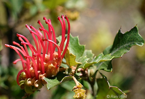
The Anglesea Grevillea (Grevillea infecunda) is an open root suckering shrub which only occurs in the Anglesea and Aireys Inlet area of Victoria, Australia.
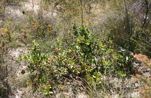
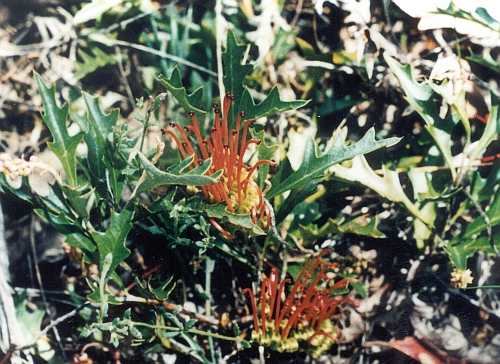
The Anglesea Grevillea grows 0.3 – 1.2m high. Leaves are dark green and hairless on the upper surface, while the lower surface is paler in colour and has a covering of sparse hairs, and are very variable in shape and size.
The Anglesea Grevillea is often confused with Holly Lomatia Lomatia ilicifolia which both occur within the same habitat (refer to images).
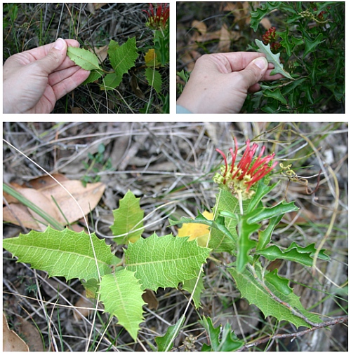
The series of photos shows the difference between Holly Lomatia leaves and Anglesea Grevillea leaves. The Holly leaves are those on the left and the Grevillea leaves are on the right. The underside of the Grevillea leaf is paler in colour.
Distribution
Ecology & Habitat
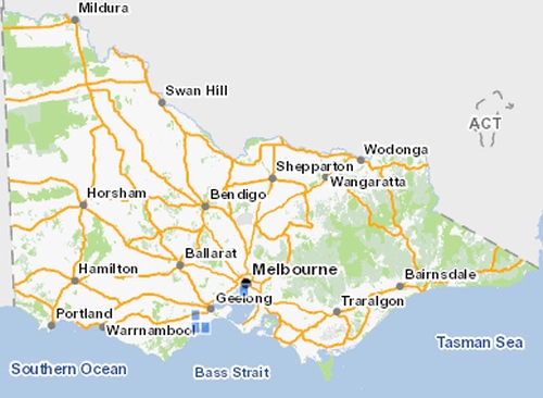
Anglesea Grevillea occurs in open areas of dry sclerophyll forest or woodland with sandy or gravelly soils in the hilly country around Anglesea and Airey’s Inlet. There are eleven known populations with plant numbers estimated at over 1,635 individuals. The populations are confined to National Park, Forest Park and other reserves in the Anglesea Aireys Inlet area.
Flowering occurs from October to December. Flowers are yellow-green to brown in colour with long, red styles. The seed produced by this plant is thought to be non-viable and it appears to reproduce only through root suckering.
Threats
Threats to Anglesea Grevillea populations include:
- Accidental damaged - mainly caused by roadside slashing, and vehicles driving over individual plants.
- Physical disturbance - caused by 4WD’s, trail bikes, horses and other recreational activities.
- Physical disturbance - earthworks, areas which have been subject to gravel removal and excessive disturbance in the Anglesea Aireys Inlet area do not support populations of the Anglesea Grevillea.
- Cinnamon fungus (Phytophthora cinnamonmi).
- Inappropriate fire regime - (too frequent or insufficient burning has been observed to be detrimental but the precise burning interval is not yet determined).
- Weed invasion
Preventing the spread of Cinnamon Fungus
Cinnamon Fungus Phytophthora cinnamonmi is a soil borne disease which attacks and kills plant roots systems. It is easily introduced to unaffected sites. To prevent its spread please brush and wash down your boots and other items which can transport soil before you walk in the bush. To further reduce the spread of PC you should always walk on existing tracks
More information on how to prevent the spread of this fungus Parks Victoria Weeds and Disease
Conservation & Management
The conservation status of Anglesea Grevillea was re-assessed from Vulnerable in 2014 to Endangered in 2020 as part of the Conservation Status Assessment Project – Victoria (DELWP 2020). It is now listed as Endangered (DELWP 2021)
- Current management actions for Anglesea Grevillea are co-ordinated through the Department of Environment, Land, Water & Planning (DELWP) Victoria in conjunction with Parks Victoria and local conservation groups such as Friends of Eastern Otways and ANGAIR.
- Monitoring known populations of Anglesea Grevillea.
- Conducting searches for additional populations in similar habitat and entering information into the relevant DELWP databases.
- Areas within the Eastern Otways National Park have been fenced off to prevent accidental or deliberate damage caused by visitors.
- Surveys are undertaken to assess impacts of Cinnamon Fungus to Anglesea Grevillea or its habitat.
- A Recovery Team has been established to assist with communication between relevant agencies.
- Community involvement and awareness.
- Continued weed control to prevent the invasion of competitive pest plants.
Surveys of the Anglesea Grevillea were conducted by ANGAIR and the Friends of Eastern Otways in 2015. More than 4 hectares of bush were surveyed to collect information on the locations of plants. An additional 500 records of Anglesea Grevillea were collected and are in the process of being added to the Victorian Biodiversity database.
References & Links
Australian Government - Species Profile and Threats Database
DELWP (2020) Provisional re-assessments of taxa as part of the Conservation Status Assessment Project – Victoria 2020, Department of Environment Land Water and Planning, Victoria.
DEPI (2014) Threatened flora advisory list - Victoria, Department of Environment and Primary Industries, Victoria.
FFG Threatened List (2024) Department of Energy, Environment and Climate Action (DEECA).
Flora and Fauna Guarantee Act 1988 Action Statement No. 204 Anglesea Grevillea pdf
VBA (2015) Victorian Biodiversity Atlas, Department of Energy, Environment and Climate Action (DEECA), 2024.
Images used with permission from Rani Hunt, Department of Energy, Environment and Climate Action (DEECA). Anglesea, Victoria.
See also:

