White Sunray
White SunrayLeucochrysum albicans subsp.albicans var. tricolor | |
|---|---|
| Kingdom: | Plantae |
| Phylum: | Magnoliophyta (Angiosperm) |
| Class: | Magnoliopsida (Dicotyledon) |
| Order: | Asterales |
| Family: | Asteraceae |
| Status | |
| Australia: | Endangered (EPBC Act 1999) |
| Victoria: | Endangered (FFG Threatened List) |
| Tasmania: | Endangered (Tasmanian Threatened Species Protection Act 1995) |
| Vic FFG: | listed; Action Statement No. 262 |
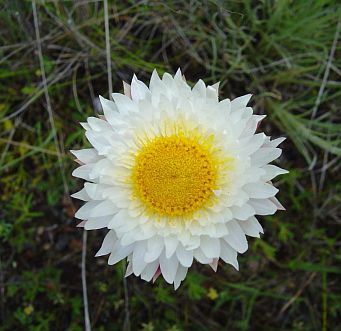
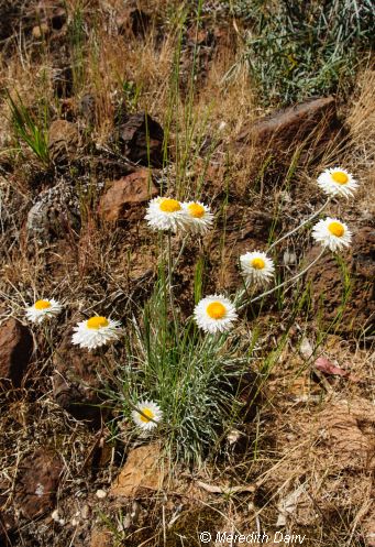
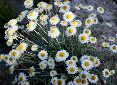
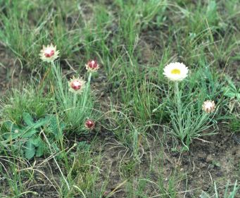
The White Sunray Leucochrysum albicans subsp.albicans var. tricolor is an erect perennial plant with greyish-green, narrow linear leaves growing to about 300mm high. In spring and summer it has long-stemmed, bright yellow flowers 25 to 40mm in diameter. Depending on the severity of summer conditions the plant can dry out after flowering.
The White Sunray also known as the Hoary Sunray Leucochrysum albicans, (formerly Helipterum albicans) is s closley related to three recognised subspecies considered threatened in Victoria:
White Sunray - Leucochrysum albicans subsp. albicans var. tricolor (found on Victorian Volcanic Plains)
Buffalo Sunray - Leucochrysum albicans subsp. albicans var.buffaloensis (found at Mt Buffalo).
Alpine Sunray - Leucochrysum albicans subsp. alpinum, (found only in alpine areas).
The White Sunray occurs on black volcanic soils across the Victorian Volcanic Plains bioregion. It is also known from the Midlands region of Tasmania, and in the Southern Highlands region of New South Wales and the Australian Capital Territory.
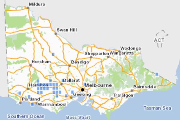
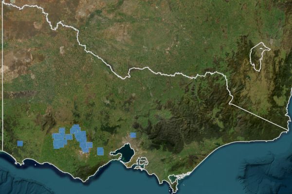
All known records of White Sunray Leucochrysum albicans subsp. albicans var. tricolor in Victoria. Source: VBA 2019.
Threats
The White Sunray has suffered extensive loss due to cultivation and pasture improvement. Many populations of White Sunray are now confined to roadsides where they are found in remnant patches of native grasslands. High levels of grassy or weedy biomass is detrimental to the reproductive success of this species as it is dependent on continual exposure of bare ground for successful seed germination.
Apart from Rokewood Cemetery all larger Victorian known populations are on roadsides. Victoria has about 20 populations containing <40,000 plants in total.
In recent years some populations have suffered a significant decline, possibly attributed to high biomass which reduces the quality of habitat. For example, a key population on the Glenelg Highway near Streatham has declined over an 8 year period, it went from approximately 4780 plants in 2003 down to 560 plants in 2011.
Continued survival of this species requires careful management of road reserves where this species is known to exist.
Priority areas and major partners in management
Roadside Management
Ararat Rural City Council
- Chatsworth area
- Maroona-Glenthompson area
- Mortlake area (in conjunction with VicRoads)
- Streatham area
- Wickliffe-Willaura area (in conjunction with VicRoads)
Corangamite Shire
- Cressy area - VicRoads
Golden Plains Shire
- Lismore area'' - VicRoads
Moyne Shire
- Hexham/Chatsworth area
- Woorndoo area
Pyrenees Shire
- Streatham area
Reserve management
- Chepstowe area - Private landholder
- Inverleigh Flora Reserve - Parks Victoria, Golden Plains Shire
- Rokewood Cemetery - Rokewood Cemetery trust
- Wickliffe Township Grassy Woodlands - Ballarat Environment Network
Conservation of the White Sunray in Victoria
- Monitor sites to assess threats and determine the health of populations.
- Identify disturbance regimes to maintain habitat (including investigation of different burning regimes.
- Identify other disturbance regimes to determine which method is best suited to managing sites, e.g. periodic scraping or grazing.
- Research - Encourage and support research and disseminate results at scientific meetings and in journals.
- Control threats from pest plants, using application of herbicide/hand removal of weeds.
Recent management outcomes
Population monitoring
At present 16 sites are monitored to gauge the impact of threats, determine the health of the populations and recommend management actions. Most monitoring is carried out by biodiversity officers from the Department of Environment, Land, Water and Planning, sometimes with assistance from community conservation groups.
In January 2011 a population monitoring survey of White Sunray was conducted by DELWP Biodiversity Officers at managed locations across the Glenelg Hopkins Catchment Management Authority region.
The number of plants recorded at the majority of high priority locations was significantly lower than the previous survey in 2010. This is in contrast to populations in other catchment areas, where the number of plants recorded was higher than the 2010 surveys.
In the summer of 2011 a new population of the White Sunray was discovered along the Hamilton Highway, east of Mortlake. Approximately 140 plants were counted. The population was mapped and VicRoads advised to ensure on-going protection of this population.
Surveys in 2012 found the incursion of highly competitive environmental weeds is posing a significant threat to the White Sunray at many sites.
Weed control
In 2011, the DSE now DEECA and VicRoads worked together to control woody weeds (predominately non-endemic Eucalypt species) at number of roadside populations to enhance White Sunray habitat.
In 2012, a survey of the Mortlake-Ararat Road population showed significant encroachment of woody weeds including Radiata Pine Pinus radiata. Dense infestations of pine seedlings significantly alter the structure, composition and integrity of this grassland by promoting exotic pasture grass species such as Phalaris and Fog-grass. These treatable infestations will be nominated as a priority for weed control in coming years.
In 2012 and 2013 the DWELP (now DEECA) and VicRoads carried out strategic weed control targeting predominately annual exotic pasture grasses at several White Sunray sites, including Chatsworth-Wickliffe Road, Eurabeam-Streatham Road, Mortlake-Ararat Road and Woorndoo Road Reserve, Glenelg Highway east of Wickliffe and Chatsworth-Wickliffe Road
Revegetation
Efforts to increase the number of White Sunray populations on the Volcanic Plains has been undertaken by the Trust for Nature in a two year project funded through its Land Management Innovation Fund. The Trust has been working with a number of TFN covenant landholders who have been willing to support reintroduction of White Sunray to their properties.
In 2012, 600 White Sunray plants were planted during autumn / winter across 6 grassland properties (some with multiple sites) in the VVP region of Corangamite. Almost all of these plants grew well and survived to flower and dropped seed in spring 2012. In order to increase the likelihood of establishing viable self sustaining populations another 360 plants were planted in 2013 into the areas that had grown the best. In the autumn of 2013 three new landholders with recent Trust for Nature covenants were also added to the project to increase the chances of success.
TFN White Sunray project contact: Libby Woodward, 0438 507 898.
Direct seeding
Greening Australia, through their Grassy Groundcover Restoration Project have undertaken a number of successful direct seedings using White Sunray across the Basalt Plains with most resulting in expanding populations.
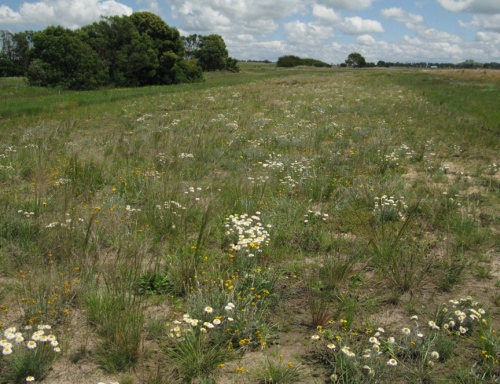
Direct seeding restoration site including White Sunray on roadside near Wickliffe. Image:Paul Gibson-Roy
In 2013/14 Greening Australia with the support of VicRoads undertook restoration of two roadside plots on the Hamilton Highway at Duverney (about 5km west of Cressy). The project involved restoration of about 2.5 hectares of Plains Grassland with the specific aim to expand the range of the White Sunray. Two plots were scraped to a depth of approximately 100mm and a number of non-indigenous trees were removed. The sites were reseeded with native grasses and forbs. Monitoring in November 2014 found a good diversity of native species with 11 species at one site and 15 species at the second site, in both cases exceeding that of the immediate surrounding remnant grassland vegetation. Surveys also estimated the establishment of in excess of 1000 White Sunray pants per site (White 2014).
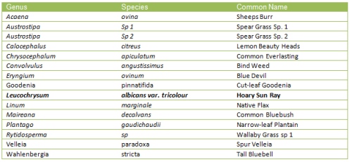
Species established on the Hamilton Highway at Duverney (about 5km west of Cressy) including the White (Hoary) Sunray
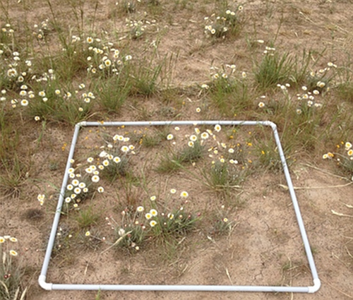
Survey of grassland rehabilitation using random quadrat method. Image: Rod White, Greening Australia
Fire management
The DEECA, VicRoads and CFA Vegetation Management Officers have worked towards the implementation of fire management, maintenance of signage and other threat abatement works.
One of the largest populations of the White Sunray in the Glenelg Hopkins catchment had an environmental burn to managing grass biomass including the invasive Toowoomba Canary Grass ''Phalaris aquatica''. This population stretches along approximately 4.5km of Willaura-Wickliffe Road and contains approx. 1,500 plants (spring 2011 count).
The Willaura-Wickliffe Road grasslands were visited by a number of local land managers and stakeholders as part of a tour run by the CFA in December 2011. The tour promoted the ecological benefits of roadside burning programs. This provided the opportunity to highlight the high conservation significance of the site and discuss management issues with the CFA Vegetation Management Officers.
References
VBA (2019) Victorian Biodiversity Atlas, Department of Energy, Environment and Climate Action (DEECA), Victoria.
VVB (2025) Visualising Victoria's Biodiversity map portal - White Sunray
White (2015) - Hamilton Highway Site Rehabilitation Final Report, November 2014, Greening Australia
More Information
- Australian Government, Species Profiles and Threats database
- National Recovery Plan
- Victorian FFG Action Statement No.262 pdf
Please contribute information regarding White Sunray in Victoria - observations, images or projects. Contact SWIFFT


