Video conference 26 April 2018 - Bird conservation
SWIFFT video conference notes are a summary of the video conference and not intended to be a definitive record of presentations made and issues discussed.
This video conference was supported through resources and technology provided by the Department of Environment, Land, Water and Planning, Victoria. SWIFFT wishes to thank speakers for their time and delivery of presentations. Thanks to Michelle Butler who chaired the session from Ballarat.
The second video conference for 2018 had a theme: Bird conservation.
Key points summary
Quick take home messages from this video conference.
Presentations
- Nominating woodland birds under the EPBC Act
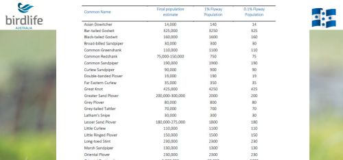
- Population Estimates for 37 listed migratory shorebird species
- Bird conservation in floodplain and riparian habitat
- Citizen Science update
List of groups/organisations in attendance
A total of 71 participants were connected across 13 locations; Ararat, Ballarat, Bendigo, Colac, Geelong, Hamilton, Heywood, Horsham, Heidelberg (Arthur Rylah Institute), Nicholson Street - Melbourne, Orbost, Traralgon and Wodonga.
Educational: Federation University, University of Melbourne.
Local Government: Banyule City.
Field Naturalist Clubs: Ballarat, Bendigo, Hamilton and Geelong.
Community Conservation Groups: Birdlife Hamilton, Birdlife East Gippsland, Ballarat Environment Network, Friends of Eastern Otways, Ararat Landcare, North Bendigo Landcare.
Conservation Organisations: Glenelg Hopkins CMA, Parks Victoria (Otways), Barwon Coast Committee, Winda-Mara Aboriginal Corporation, Department of Environment, Land, Water and Planning (DEWLP) staff across 18 locations, inc. Lonsdale Street and Arthur Rylah Institute, Heidelberg.
Industry: Brett Lane & Associates Pty Ltd., Resilience Project Services and Coliban Water.
Speaker summaries
How to protect an undefined bird community - Nominating woodland birds under the EPBC Act Hannah Fraser, Quantitative and Applied Ecology Group, University of Melbourne
Hannah spoke about the need to quantify the status of woodland birds across Australia and address concerns about the general decline of woodland birds through nomination and Listing of Woodland Birds under the Environment Protection and Biodiversity Conservation Act 1999 (EPBC Act).
Key steps
- Agree on a woodland bird ecological community (which species are included).
- Assess the threat level and determine which EPBC Threat Criteria Apply.
- If woodland bird communities are threatened then List as a Threatened Ecological Community under the EPBC Act.
How do we protect woodland birds?
Some States have listed protections for what they consider the Woodland Bird Community. For example, in Victoria the Flora & Fauna Guarantee Act 1988 lists the Woodland Bird Community but it omits some species and includes some that are not woodland birds.
National level protection
National protection level is important because some species migrate across large areas and use habitat in a variety of States. It also helps to provide a consistent approach to those species defined as Woodland Birds and afford the same protection measures across Australia.
Agree on a woodland bird ecological community
One of the key steps in preparing documents for the EPBC Act was to define what species comprised the woodland bird community. As part of her research Hannah undertook a systematic review of woodland bird studies and found there were many interpretations of which species were woodland birds. Hannah created lists of which species which were considered woodland birds or not. These lists formed the basis of a process to achieve protection under the EPBC Act.
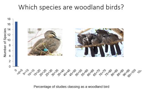
Hanna spoke about the process of determining the Woodland Bird Community through collaboration with leading bird ecologists, including workshops and surveys to refine lists of woodland birds and come up with an agreed consensus of what species would be included, the condition of the woodland bird community and threat levels.
Six sub-divisions of the Woodland Bird Community were identified across Australia based on habitat, different history of clearing and development, also slightly different species composition in Tasmania and Western Australia. Hannah emphasised that the listing would be for the Woodland Bird Community as a whole.
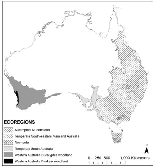
Six sub-divisions of the Woodland Bird Community were identified across Australia.
At the end of the collaboration process the final list comprised 208 species to be included as part of the Woodland Bird Community. The process further refined that if a site supported 70% of the 208 species it could be considered a Woodland Bird Community.
Assess threat level
Hanna spoke about the threat criteria under the EPBC Act and applying the criteria to woodland birds. The focus of applying threat criteria to the nomination was on points 1, 3 ,4 and 5
Which EPBC Threat Criteria Apply?
- Decline in geographic distribution
- Small geographic distribution plus threat (range too large)
- Loss or decline of functionally important species
- Reduction in community integrity
- Rate of continuing detrimental change
- Quantitative analysis showing probability of extinction (not feasible)
For this presentation Hanna focused on points 1. Decline in geographic distribution and 4. Reduction in community integrity.
Criteria 1 Decline in geographic distribution
Hanna spoke about the change to tree cover across Australia since 1750. This was used as a conservative estimate to where the maximum cover of woodland birds would have been. Based on the EPBC Criteria of 50% decline or more in geographic extent since 1750 the whole woodland bird community across Australia does not qualify as threatened. (There must be 50% decline or more to qualify as vulnerable, 70% or more – endangered, 90% or more – critically endangered).
Hanna pointed out that some of the sub-regions did not meet the criteria whilst others did. But taken as a whole the decline in geographic decline does not qualify.
- Subtropical Queensland: 41% decline since 1750 - does not meet criteria
- Temperate south-east mainland: 51% decline since 1750 - Vulnerable
- Temperate South Australia: 70% decline since 1750 - Endangered
- Tasmania: 32% declines since 1750 - does not meet criteria
- South-west Western Australia Eucalyptus: 38% decline since 1750 - does not meet criteria
- South-west Western Australia Banksia: 63% decline since 1750 – Vulnerable
Criteria 4 Reduction in community integrity
Hanna discussed changes to woodland bird habitat which include weed invasion, on-going grazing of habitat and Noisy Minor invasion. A group of experts undertook a process of rating woodlands based on species lists from current and historical survey data (species richness, proportion of species < 50 grams which are Noisy Minor vulnerable species, species more common in intact woodlands, species more common in degraded woodlands). From this work a formula was derived which could be applied to a 2-hectare 20 min. bird survey used to rate the condition of a woodland bird community from 0% to 100% (Low condition 0-25%, Moderate 25-60%, High 50-75% and Pristine 75-100%).
Calculations were undertaken to determine the condition of the woodland bird community over different time periods to ascertain the change in condition over time. This work was repeated for each of the 6 ecoregions. Two examples are shown below.
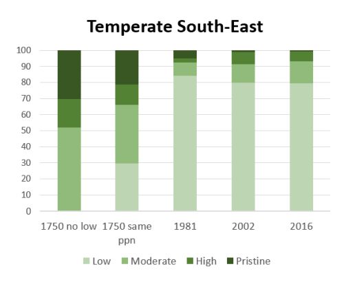
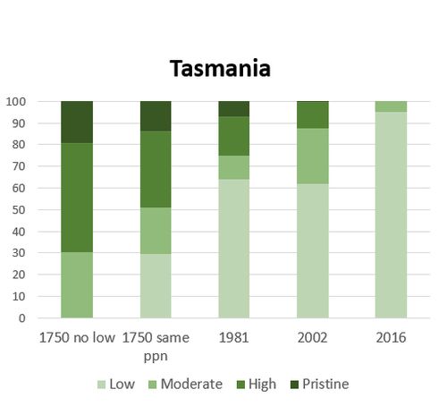
The proportion of woodland bird community in Low condition has increased dramatically and the proportion in Pristine condition has declined to a very low level. In South-eastern the condition has remained reasonably similar since 2002 but in Tasmania the condition has deteriorated.
Is the woodland bird community threatened based on decline in community integrity? (Between 1750 and 2016) – yes
Hannah explained that to apply the EPBC Act Criteria based on decline in community integrity there must have been a decline of 50% which can’t be recoverable in the near or medium future.
Subtropical Queensland:
- % community in >75% condition decreased from 20% to 3%
- % community in <25% condition increased from 28% to 78%
Temperate south-east mainland:
- % community in 75%+ condition decreased from 21% to 1%
- % community in <25% condition increased from 30% to 79%
Temperate South Australia:
- % community in 75%+ condition decreased from 10% to 0%
- % community in <25% condition increased from 38% to 93%
Tasmania:
- % community in 75%+ condition decreased from 14% to 0%
- % community in <25% condition increased from 30% to 95%
South-west Western Australia Eucalyptus:
- % community in 75%+ condition decreased from 22% to 0%
- % community in <25% condition increased from 0% to 55%
South-west Western Australia Banksia:
- % community in 75%+ condition decreased from 15% to 0%
- % community in <25% condition increased from 0% to 68%
All communities have experienced at least a severe (50% decline): Endangered
Based on the changes in community integrity the woodland bird community is threatened and a Nomination to the EPBC Act was submitted in 2017.
Hannah thanked the team members who have worked on this project.
Key points from questions
- The bird survey effort in Tasmania could have dropped off for woodland birds with more focus on seabirds.
- The 1750 bird community condition was worked out using a number of scenarios, the most conservative being based on bird data from remnant woodlands (tree cover) in 1981 and scaled to determine the woodland bird condition relating to changes in habitat. (This is a fairly complicated process – refer to Nomination for full details).
- Mapping of woodland bird habitat is an additional step once the Nomination is endorsed.
- The distribution of bird records varies across Australia, with more remote areas having less records.
Revision of the East Asian-Australasian Flyway Population Estimates for 37 listed Migratory Shorebird Species - Birgita Hansen, Federation University, Australia.
Birgita presented her talk on behalf of the team (Danny Rogers, Rich Fuller, Doug Watkins, Dan Weller, Rob Clemens, Mike Newman and Eric Woehler) which included people from the University of Queensland, Arthur Rylah Institute, Birdlife Australia and the Australasian Wader Studies Group.
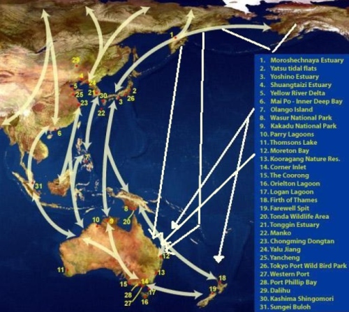
East Asian-Australasian Flyway
The need for population estimates
The project was carried out for the Department of Environment & Energy in 2016 to revise the population estimates for the 37 migratory species currently Listed under the Environment Protection Biodiversity Conservation Act 1999 (EPBC Act). Migratory species are included under matters of National Environmental Significance under the EPBC Act, there are also several species Listed as Vulnerable, Endangered and Critically Endangered.
In order to assess the level of impact from a proposed action it is necessary to understand what proportion of the population is supported at any particular site and the global population. Population estimates are critically important to underpin the thresholds for the Act. For example, for migratory shorebirds the EPBC Act is triggered if the site supports 0.1% of a Nationally important site or 1% of an Internationally important site.
Population estimates need to be updated regularly to understand changes in populations, distribution and abundance. Population estimates are used in International agreements such as Ramsar, they also enable legislation to reflect the most current knowledge of populations.
Birgita spoke about the rapid and significant declines across a whole range of shorebird species in recent years. These declines are recorded despite there being more data available from increased shorebird monitoring.
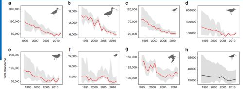
Many species of shorebirds have experienced a rapid decline in population. Source: Studds et. al, 2017 Nature Communication 8.
Overall approach
Birgita discussed the data used in the project which included summaries from existing count data (Australia and overseas) and estimated extent of unsurveyed coastal shorebird habitat. Modelling of Australian inland population and analysis of population size using breeding distributions and densities. Information from breeding grounds was also used. An expert review process was used throughout the entire process.
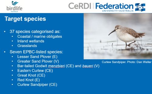
Data sources
- Shorebirds2020 (previously the AWSG population monitoring program) 1971- present
- Queensland Wader Study Group data 1981 - present
- Ornithological Society of New Zealand 1983 - present
- Asian Waterbird Census (AWC) 1984 - present
- Other published and unpublished sources not in these databases, e.g.: Ashmore Reef, Northern Territory coastline and Gulf of Carpentaria
Birgita pointed out that most the data have been collected by volunteers over the years which represents a massive volunteer effort and one of the longest running citizen science programs in Australia.
Analytical steps
Birgita discussed the analytical process in some detail (only brief summary here).
Modelling count data – used the most recent data, focus between November to March when populations are at terminus sites and most stable.
Intertidal modelling - intertidal mapping (actual and modelled) overlaid with Australian shorebird area mapping and point count locations for other countries.
Inland modelling (Australia) - targeted 14 species that use inland habitats, modelled abundance at inland sites using count data and rainfall.
Expert review – two workshops covering planning and analytical approach, also assessed results of first major analyses. Estimates and extrapolations were circulated for comment and feedback, adjustment made where necessary.
Breeding distribution & density – use of Birdlife International mapping of breeding range to work out relationship between population size estimate, breeding range and density within the flyway. Estimated flyway populations for 19 species.
Selection of best estimates – for coastal obligates in Australia - spatially extrapolated counts. For non-coastal obligates - breeding range and density estimates were used. Where there was insufficient count data for applying spatial extrapolations, breeding range and density estimates were used.
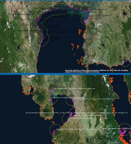
Examples of intertidal mapping in South-east Asia (Gulf of Thailand - top), buffered point count locations overlayed with inter-tidal mapping within count area (pink) and outside count area (orange). This information is used to calculate the proportion of intertidal area overlapping with survey area polygons.
Overview of data summaries
The count coverage was extremely variable despite there being a lot more data over many more sites. The Northern Territory still remains an area where there are large data gaps. Overseas there are many areas across Asia which are poorly covered by counts e.g. only 4% coverage in Indonesia. The team undertook substantial adjustments to state-based estimates and extrapolation figures which were very conservative.
Overview of breeding population
Birgita spoke about the fact that some of the flyway totals from count data were so low that breeding population counts were used in the population estimates.
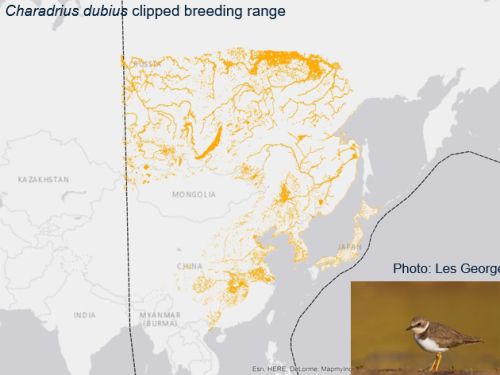
Example of mapping of breeding range of Little Ringed Plover clipped for the East Asian Australasian Flyway.
Rationale to final selection
The combined knowledge of the team and expert reviewers was used to determine the best estimate for each of the 37 species using information from modelling, counts and breeding grounds.
Quick View population estimates or View full report
Using the new estimates
Birgita emphasised the new population estimates have been derived from completely different methods and data. They should not be used to compare against old estimates to infer trends.
Birgita acknowledged the people involved in the project, from the counters and coordinators that make the shorebird surveys happen to those involved in workshops, modelling and reviewing the work. She also thanked supporters of the project.
Key points from questions
- There are many instances of degradation to coastal intertidal areas across south-east Asia and China. Whilst coastal reclamation is more obvious there is little data being gathered on loss of inland habitat (diversions and drainage of inland waters).
- The focus of this project was migratory shorebird species Listed under the EPBC Act. Further work is required to gain new population estimates for endemic Australian shorebirds e.g. Hooded Plover.
- Data sharing arrangements are in place for many overseas countries but the biggest problem is the lack of resources in many countries to collect the information. We need to look at filling knowledge gaps and work with other countries where possible.
- In Australia, Regional counters and co-ordinators were consulted regarding extrapolated figures. The same process was not possible in Asia.
- The new population estimates will be used in site assessment listings.
- There are a number of international groups involved with counting who welcome self-funded visitors to assist with counts.
Relevant reports
Revision of the East Asian-Australasian Flyway Population Estimates for 37 listed Migratory Shorebird Species Hansen et al. 2016
Rapid population decline in migratory shorebirds relying on Yellow Sea tidal mudflats as stopover sites. Studds et al. 2017
SWIFFT video conference notes April 2015 – Migratory shorebirds
Identifying opportunities for bird conservation in floodplain and riparian habitat - Dr Katherine Selwood, University of Melbourne
Katherine focused on the Murray-Darling Basin and spoke about the massive reductions in water flow which are now only about one third of what they once were. With added impacts from climate change the incidence of higher temperatures, less winter rainfall, more time in drought and more frequent droughts in the area the system is going to suffer even less water with a possible further 11% reduction by 2030.
Reduced flows mean less water for the environment leading to highly degraded instream and floodplain ecosystems.
Decline in floodplain forest stand condition
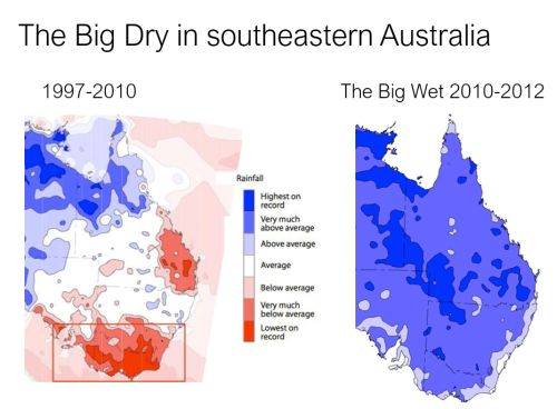
Katherine spoke about the longest and most sever drought on record (1997- 2010) which resulted in flows in the Murray River being 50% lower than the long-term average. The drought was broken in 2010 with higher than average rainfall.
Work led by Shaun Cunningham (published S. C. Cunningham et al. (2018) Land degradation and development) studied the condition of floodplain forest stands at a number of sites throughout the drought. Studies found that since 1990 there has been a steady decline of forest stands in good condition on the Murray River with more pronounced declines since the big dry.
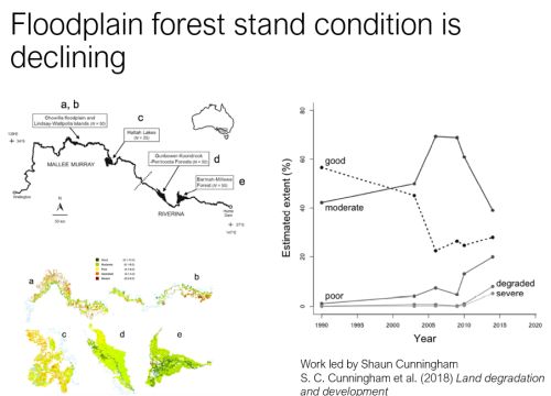
Forest stand condition monitoring sites. Chart demonstrating a rise in the extent of degraded sites and decline in moderate and good sites.
Links between forest condition and bird species richness
Katherine spoke about links between floodplain forest condition and woodland bird species richness, abundance and breeding activity (Mac Nally et al. 2014) there were also studies regarding Antechinus demography (Lada et al. 2014) and understory plant species.
Katherine’s work studied bird data at Gunbower Island and how birds responded to the drought between 1998 to 2009 and again after the big wet post 2013. The aim was to measure how birds responded to the drought and measure resistance (degree of decline) during and after the drought. During the Big Dry 22 of 31 spp. (71%) declined. After the Big Wet 2 of 22 spp. recovered completely; 3 had incomplete recoveries, 17 spp. (77%) did not recover. Also, studies found there was no increase in breeding activity after the big wet.
A large proportion of floodplain birds declined during the Big Dry and largely failed to recover.
Further studies were carried out in 2017 to see if there is any change in recovery but results have not been analysed yet.
Floodplains as drought refuges
Katherine discussed the need to compare how declines of bird species at the study sites compare to forests in the wider region at the time of the big dry. Bird Atlas data was used to analyse trends for 144 terrestrial bird species between 1998 -2013 for the entire Murray-Darling Basin. The study looked at species present in both zones, floodplain vs. non-floodplain.
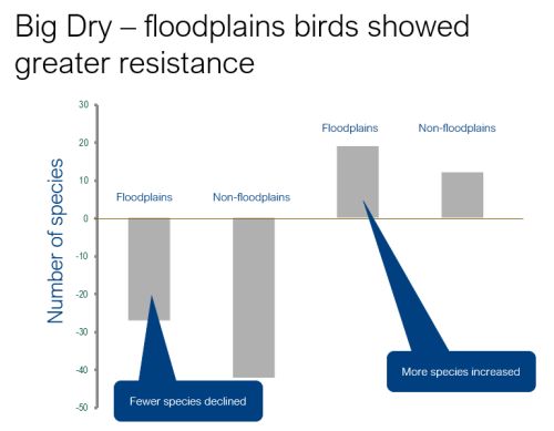
Bird species declined in both floodplain and non-floodplain habitat during the big dry but less species declined on floodplain habitat. After the big wet more species increased on floodplain habitat.
Katherine discussed the movement of 3 species (White-naped Honeyeater, Grey Currawong, Golden Whistler) onto the floodplain during the big dry and off the floodplain after the wet.
Green tongues into the arid zone
Katherine spoke about where bird species occur throughout the Murray-Darling Basin. Using Birdlife data, she was able to determine that floodplain areas have the capacity to carry some species into dry areas further than they would otherwise occur.
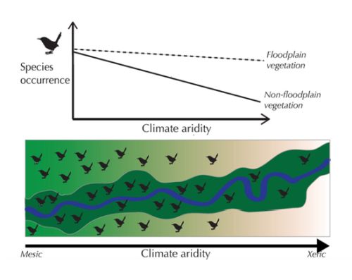
Using Bird Atlas data from the Murray Darling Basin for 1998-2013: Murray and Darling River corridors Katherine found aridity had a negative effect on the occurrence of 58 species (45%) of overall species. 22 species (38%) had the effects of aridity moderated in floodplains.
Key points
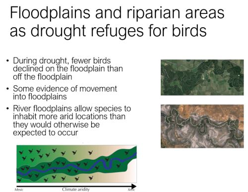
Katherine spoke about some work she did with Parks Victoria to look at forest condition modelling based on Shaun Cunningham’s work between 2003 to 2012 to identify areas of importance on the floodplain which serve as havens during droughts. This type of work is important as provides land managers with information they need, particularly in drought conditions.
Returning water to the environment
Katherine felt that with the introduction of the Water Act and the Murray-Darling Basin Plan some water is being returned back to the environment so things are looking a bit better than they have in recent decades. Key environmental water holders; Murray-Darling Basin Authority, Commonwealth Environmental Water Holder and States e.g. Victorian Environmental Water Holder can now look at how best to achieve environmental objectives for river connectivity, waterbirds, vegetation and fish. Katherine is also interested in how we can have environmental gains for terrestrial fauna on floodplains, particularly threatened birds.
New project
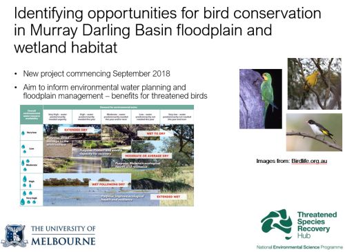
The focus of the project will be threatened bird species. The project will work closely with Environmental Water holders and the wetlands Ramsar area of the Department of Environment & Energy achieve gains for threatened birds. The project involves an inventory of threatened birds occurring in the Murray-Darling Basin floodplains and wetlands. Mapping the occurrences during drought and wet periods and identifying high priority floodplains and wetlands in drought (refugia) and wet periods.
Contact: Katherine Selwood
Key points from questions
- The Bird Atlas coverage in the Murray-Darling is reasonably extensive with tens of thousands of records with good time coverage.
- There is some difficulty in encompassing all riparian areas over such a large-scale area. Flood frequency was mainly used in this project. Findings from this research should apply to riparian areas because they have high productivity and micro climate conditions, birds may well be utilising riparian areas on very hot days.
- Concern regarding theft of environmental water is probably reduced for specific environmental water events as they are monitored, but there could be more of an issue when it comes to flows.
Related reports
Effects of the drought on woodland birds. K. Selwood, R Clarke, S. Cunningham, H. Lada, M. McGeoch, R. Mac Nally (2015) Journal of Animal Ecology Wiley on-line library
CSIRO (2008) Water availability in the Murray-Darling Basin pdf
Assessment of ecosystems: A system for rigorous and rapid mapping of floodplain forest condition for Australia's most important river. S. C. Cunningham et al. (2018) Land degradation and development Wiley on-line library
Citizen Science update - Fern Hames, Arthur Rylah Institute, DELWP
Fern provided some updates on Citizen Science activities being undertaken at ARI.
Scoping paper developed for people in DELWP, there is also a brochure for external use ‘Citizen Science: You and nature’ which outlines the benefits of citizen science projects (to both participants and scientists), how an effective citizen science programs can be created.
'Citizen Science: You and nature’ Brochure pdf
Fern encouraged anyone interested in Citizen Science to join the new Victorian Chapter of the Australian Citizen Science Association. Contact: Victorian Chapter e-mail
Australian Citizen Science Association
Pilot Projects
Fern spoke about the recreational fishers Citizen Science project involving otoliths from Murray Cod and Golden Perch to assist with fisheries research & management.
SWIFFT video conference notes 1 Feb. 2018 ‘Rec fishers fishing for fish earbones’
Research on Citizen Science
ARI has a Monash University student looking at behavioural change and how it relates to Citizen Science.
Citizen Science Workshop 14-15 June 2018
Day 1 – invited participants will be looking at knowledge gaps and priorities relating to Victoria’s biodiversity strategy and identifying knowledge gaps that could be filled with citizen science.
Day 2 – opportunity for people delivering key citizen science projects across Victoria to come together share ideas and scope new projects relating to the Biodiversity Strategy.
For more information regarding the workshop e-mail Fern Hames
Key points summary
| 208 species have been recognised as being part of Australia’s Woodland Bird Community. |
| The woodland bird community is considered threatened (endangered) based on the decline in community integrity. A Nomination to the EPBC Act was submitted in 2017. |
| Population estimates for the 37 migratory species currently Listed under the (EPBC Act 1999) were reviewed in 2016 using new analytical processes. |
| There have been rapid and significant declines across a whole range of shorebird species in recent years. |
| A large proportion of floodplain birds in the Murray-Darling declined during the Big Dry and largely failed to recover. |
| Floodplain areas have the capacity to carry some species into dry areas further than they would otherwise occur. |
About SWIFFT video conferences


